Why Landlocked Countries Depend on Routes Beyond Their Borders
A simple route map shows how landlocked countries reach ports, where neighbours shape access, and which alternatives can keep trade connected.
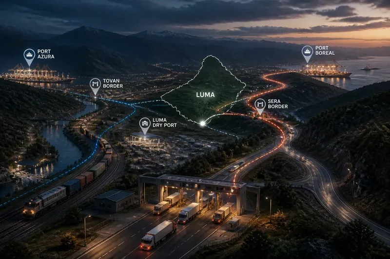
How does a landlocked country reach a seaport, and what happens if the route depends on a neighbour? A simple route map makes the answer visible: it traces the roads, railways, border crossings and ports that connect a country to the wider world, while showing where access depends on decisions beyond its borders.
For a country without a coastline, geography does not end at the national boundary. Its practical connection to maritime trade runs through other places, and each link brings its own opportunities and constraints. The map is useful not because it predicts every disruption, but because it shows which connections matter and where choices are limited.
1. Draw the whole route
Start with a blank map, mark the landlocked country, and add the nearest plausible seaports. Then trace the routes between them: a railway may cross one neighbour, while a road corridor reaches a different port through another state. Include inland waterways where they form part of the journey, and mark border crossings rather than treating the line between countries as a single open passage.
This is a route map, not just a map of borders. A neighbouring country may be close in distance yet difficult to cross if the route is indirect or the transport links do not connect. A more distant port may be more practical if a reliable rail corridor leads to it. As with a household keyring, having several keys matters only if one fits the door you need to open.
For each route, draw arrows in both directions. Imports travel inland from a port; exports travel towards it. The reverse direction matters because cargo, equipment and transport capacity may be needed to make return journeys workable. A route that looks useful for one direction alone may not serve the country’s trade as well as it first appears.
2. Mark every crossing
Next, label every national border the route crosses. A corridor that passes through one transit country creates a different set of dependencies from a route that crosses several. Each crossing can involve document checks, customs procedures, vehicle or rail arrangements, and coordination between agencies in neighbouring states.
Here, transit means passage through a country between the landlocked country and a destination or port. It differs from access to a port itself: a state may agree to let goods cross its territory while separate arrangements govern how those goods enter, leave or use facilities at the port. The distinction matters when reading agreements and tracing who controls each part of a journey.
Imagine a fictional country called Luma. Its main road to a port crosses the neighbour Sera, while a railway reaches another port through both Sera and Tovan. On a route map, Luma’s road has one foreign border to manage; the railway has two. That does not make the road automatically better, but it makes clear where the railway needs cooperation from more governments.
3. Separate route layers
Do not draw every mode as one line. Use a distinct line or colour for road, rail and water connections, and mark where cargo changes mode. These transfer points can be important: a railway may end inland, for example, leaving freight to continue by road. The route still reaches a port, but it depends on the links between transport systems as well as on the tracks themselves.
Then mark supporting facilities that affect continuity: dry ports, inland customs depots, storage sites and border terminals. A dry port is an inland facility that handles some port-related cargo or customs functions, linking a seaport with places farther inland. It can bring parts of the logistics process closer to businesses, but it does not remove the need for a route across neighbouring territory.
Keep the map selective. Its purpose is to explain connection, not to become a catalogue of every road and warehouse. A port, a crossing, a transfer point and a change of transport mode are usually enough to show why two routes that look similar on a political map may work differently in practice.
4. Compare the corridors
A useful comparison asks more than which port is nearest. Look at the number of borders, the transport modes available, the availability of alternative links, and whether the route depends on a single crossing or facility. Also note whether the corridor connects to destinations that matter to the country’s trade. The most direct line on paper may not be the most adaptable connection.
Access can be shaped by several kinds of arrangements. Transit agreements can set terms for passage; customs cooperation can affect how documents are handled; and infrastructure agreements may cover rail links, roads or terminals. These arrangements are distinct, so a route map should not imply that a political promise about transit automatically provides every practical connection a trader needs.
For a fictional Luma, suppose the Sera road route has a second border crossing available farther north, while the Tovan railway depends on one shared junction. The map reveals a choice: the railway offers a different mode and port, but the road has an alternative crossing. The country could value both connections for different reasons rather than naming one as the universal winner.
5. Trace the weak links
Mark places where a route could be interrupted: a border crossing with no nearby alternative, a rail junction shared by several connections, or a section that depends on a single neighbouring state. This is not a prediction that disruption will occur. It is a way to see where a local delay, policy change or infrastructure problem could affect a much longer journey.
Distinguish a weak link from a difficult one. A long route may be inconvenient yet still have several usable alternatives; a short corridor may be vulnerable if everything depends on one crossing. A map can show the structure of that dependence, though it cannot tell you by itself how quickly agencies, carriers or neighbouring governments would respond.
For Luma, the hypothetical map might show that both its road and railway eventually pass through the same border area, despite appearing to be separate corridors. The expected observation is that the country has two modes but shares a geographical bottleneck. That insight can change what counts as a meaningful backup: a second transport line is not a fully independent alternative if it converges on the same constrained place.
6. Read the political edges
Every route crosses jurisdictions where another government exercises authority. That makes diplomacy part of geography: a road or railway can exist physically while its usefulness depends on permissions, operating arrangements and cooperation across borders. Transit states, in turn, may seek predictable procedures, infrastructure investment or reciprocal access. The map identifies where these interests meet without assuming that every party wants the same thing.
Landlocked countries therefore have different forms of leverage, not an absence of choices. They can maintain multiple corridors, coordinate customs procedures, invest in domestic connections to border points, and take part in regional transport arrangements. Each option depends on available infrastructure and political relationships; none makes a country independent of its neighbours.
When reading a route map of a landlocked country, follow the line beyond the border rather than stopping at it. Ask which port it reaches, which states it crosses, where transport modes change, and whether another route avoids the same bottleneck. That small habit reveals the geography behind access—and why a country’s connections are often shaped as much by its neighbours as by its own map.
Questions about landlocked routes?
Does landlocked mean cut off from trade?
No. Landlocked countries can connect to seaports through neighbouring states, and they may also trade overland with nearby markets. The term describes the absence of a coastline, not an absence of external connections.
What is a transit country?
A transit country is a state crossed by goods travelling between another country and a destination or port. Its territory, infrastructure and border arrangements form part of that route.
Why can the nearest port be a poor choice?
Distance alone does not show how many borders a route crosses, which transport modes connect, or whether it relies on a single crossing. A farther port may be linked by a more workable corridor, while the closer one may require a less convenient connection.
Can a landlocked country avoid dependence on neighbours?
It cannot create a coastline, but it can reduce reliance on any single corridor by developing connections to more than one port or transit route where feasible. The route map helps distinguish genuine alternatives from lines that share the same border or bottleneck.